


QUICK FACTS
Where is it? Chicago, Illinois [41.85802928, -87.57938545]
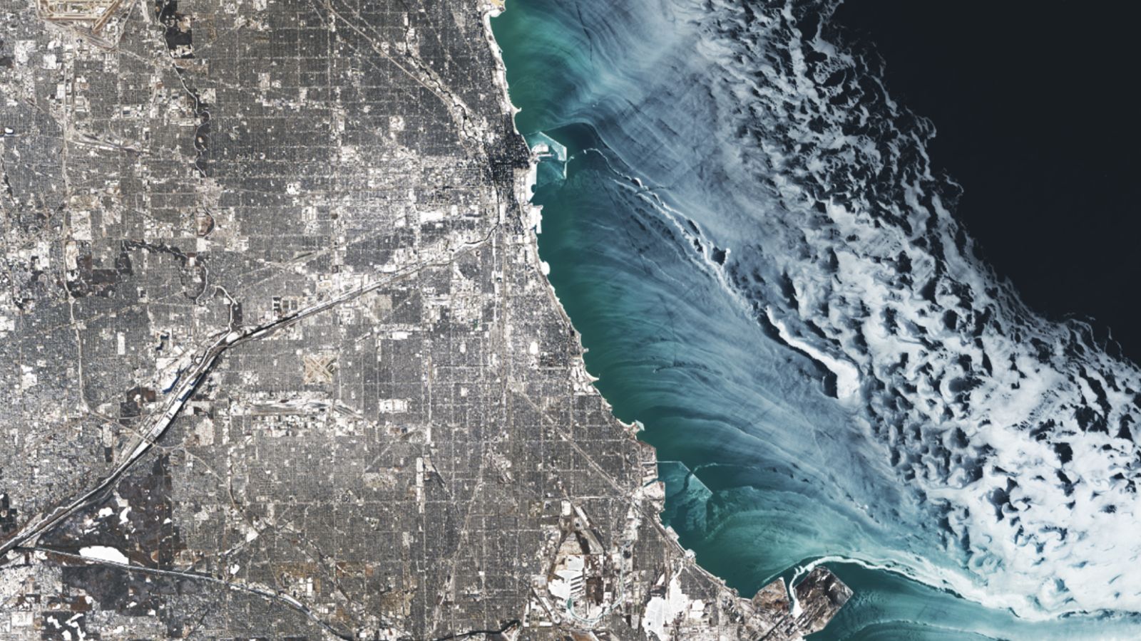
What’s in the photo? Ice swirling around the edge of Lake Michigan
Which satellite took the photo? Landsat 8
When was it taken? Jan. 24, 2025
This striking satellite photo shows rippling ribbons of ethereal ice swirling like turbulent clouds on the surface of Lake Michigan, alongside a snow-covered Chicago. The wintery scene occurred during an extreme cold snap triggered by changes to the polar vortex, experts say.
The greater Chicago region is home to around 9.5 million people and is near the southernmost end of Lake Michigan — the third-largest of the Great Lakes, which covers an area of around 22,300 square miles (57,750 square kilometers) across Illinois, Indiana, Wisconsin and Michigan.
Between Jan. 19 and Jan. 24, 2025, the Windy City and other parts of the eastern U.S. were hit by an unusual cold snap, partially triggered by a sudden expansion of the polar vortex — the persistent area of cold, low-pressure air circulating high in the stratosphere above the Arctic. During this time, temperatures in Chicago fell to as low as minus 33 degrees Fahrenheit (minus 36 degrees Celsius), according to the National Oceanic and Atmospheric Administration (NOAA).
This sudden drop in temperature, coupled with strong offshore winds, caused ice to form around the coastline and be pushed outward, creating the beautiful swirls. These flowing ribbons look a lot like clouds when viewed from above, but they are entirely ice, according to NASA’s Earth Observatory.
In total, around 20% of Lake Michigan was covered by ice when the satellite photo was taken, which is just above average for the time of year, according to NOAA’s Great Lakes Environmental Research Laboratory (GLERL).
While lake ice is common in January, the extent of ice on Lake Michigan doesn’t normally peak until February or March. It is also more common to see uniform sheets of ice rather than the flowing patterns visible in this image.
In this case, the darker, wispy ice near the lakeshore likely accumulated into thicker offshore constructs with rough edges that appear more white when viewed from above, Jia Wang, an ice climatologist at GLERL, told the Earth Observatory.
Other Great Lakes were also impacted by the cold snap, including Lake Erie, which saw up to 80% of its surface frozen, according to GLERL. Erie’s ice was so thick and emerged so quickly that a Canadian cargo freighter was trapped in place for three days, according to the New York Times.
This is not the first time that satellite photos have revealed something unusual about Lake Michigan. In 2024, aerial images helped researchers identify more than 40 mysterious craters scattered across the lake’s bed, which currently have no definitive explanation.
The low temperatures and strong winds around Chicago can also cause other unusual winter sights, such as bizarre chess piece-like sand sculptures along Lake Michigan’s beaches, known as “hoodoos,” which form when frozen chunks of sand are exposed to strong gusts.
For more incredible satellite photos and astronaut images, check out our Earth from space archives.


