




Follow us
Add us as a preferred source on Google
Subscribe to our newsletter
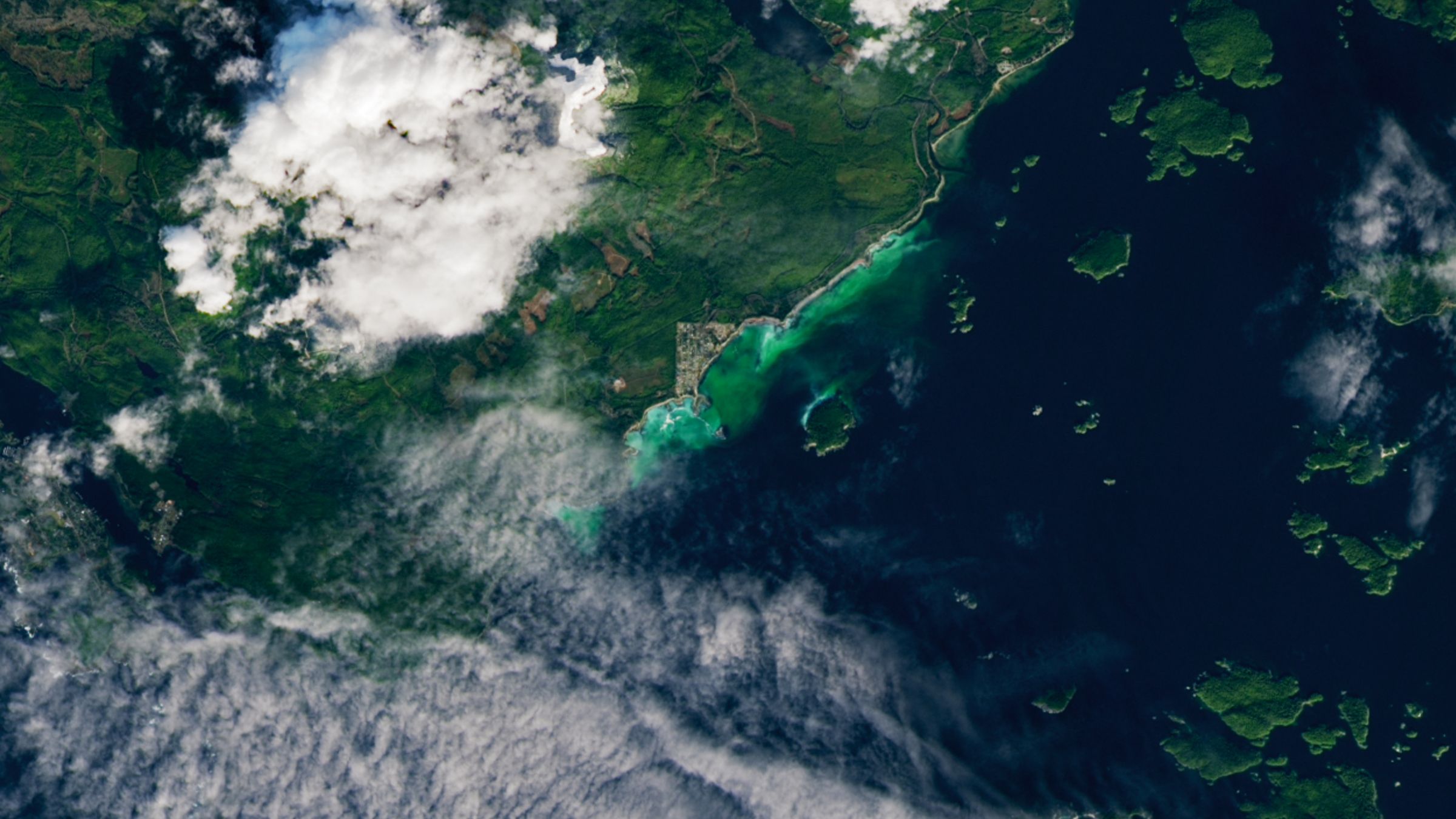
QUICK FACTS
Where is it? Vancouver Island, British Columbia, Canada [48.95586624, -125.42994277]
What’s in the photo? A green cloud of milt (fish sperm) and eggs during a Pacific herring spawning event
Which satellite took the photo? Landsat 9
When was it taken? Feb. 19, 2026
This surprising satellite snap shows a giant underwater plume of fish sperm that seems to glow green beneath the waves. The colorful cloud appeared during a spawning event at a reproductive “sweet spot” along Canada’s western coastline.
The striking sight was spotted in Barkley Sound, along a section of the southern coast of Vancouver Island in British Columbia, roughly 45 miles (70 kilometers) north of the U.S. border. The bright-green cloud is the most concentrated between Salmon Beach — the triangular town in the center of the image — and the smaller Forbes Island, which is also “glowing” along its northern coast.
The green cloud is around 4 miles (7 km) from end to end and is made of milt — a fluid containing sperm made by fish, mollusks and other aquatic animals — that was released during a Pacific herring (Clupea pallasii) spawning event. Like many other fish species, Pacific herring reproduce by congregating in large groups. The females lay eggs, which stick to kelp, sea grasses and rocky surfaces, before the males release their milt, which disperses over the area and fertilizes the eggs.
Pacific herring, which grow to around 10 inches (25 centimeters) long, often congregate in this spot off Vancouver Island in late winter or early spring, gathering for several weeks before releasing their gametes, or sex cells, according to NASA’s Earth Observatory.
“The herring spawn is a really fabulous time to be out here,” local resident Ryan Cutler, who used a drone to capture close-up photos of this year’s spawning event (see below), told CBC News. “It’s a really, really spectacular time to be around.”
The cloud of milt arguably looks even more imposing up close, as you can see in this drone photo from resident Ryan Cutler, who described the spawning event as “fabulous” and “spectacular.”
(Image credit: Ryan Cutler via Earth Observatory)
Spawning events can last anywhere between a few hours and several days, and scientists are increasingly turning to satellite images to help monitor these occurrences, according to the Earth Observatory. In this case, the milt cloud was visible for around 48 hours.
While the milky substance appears a striking green in these images, it is actually white. It appears green only because it is closer to the surface than the surrounding seafloor, meaning that less reflected light is absorbed by the water. This is also why shallow patches of water often appear turquoise when viewed from above.
Get the world’s most fascinating discoveries delivered straight to your inbox.
The coastline alongside Salmon Beach is perfect for herring to spawn because it strikes the perfect balance between a number of important factors. “Herrings prefer spawning locations that are more protected, have rocky substrate, and allow them to select areas with reduced salinity,” Jessica Moffatt, a biologist with Vancouver Island’s Island Marine Aquatic Working Group, told the Earth Observatory. “Barkley Sound hits the ‘sweet spot’ in many of these regards.”
The Pacific herring is an important species in this region; it is a primary food source for Chinook salmon (Oncorhynchus tshawytscha), which give Salmon Beach its name. The herring are also hunted by local First Nation groups, according to CBC News.
During the spawning events, a wide range of other predatory marine life — including large fish, whales and sea lions — are drawn to the area to feast on the herring, according to the Earth Observatory. And on land, eagles, wolves and bears are more likely to appear during the mass reproduction event.

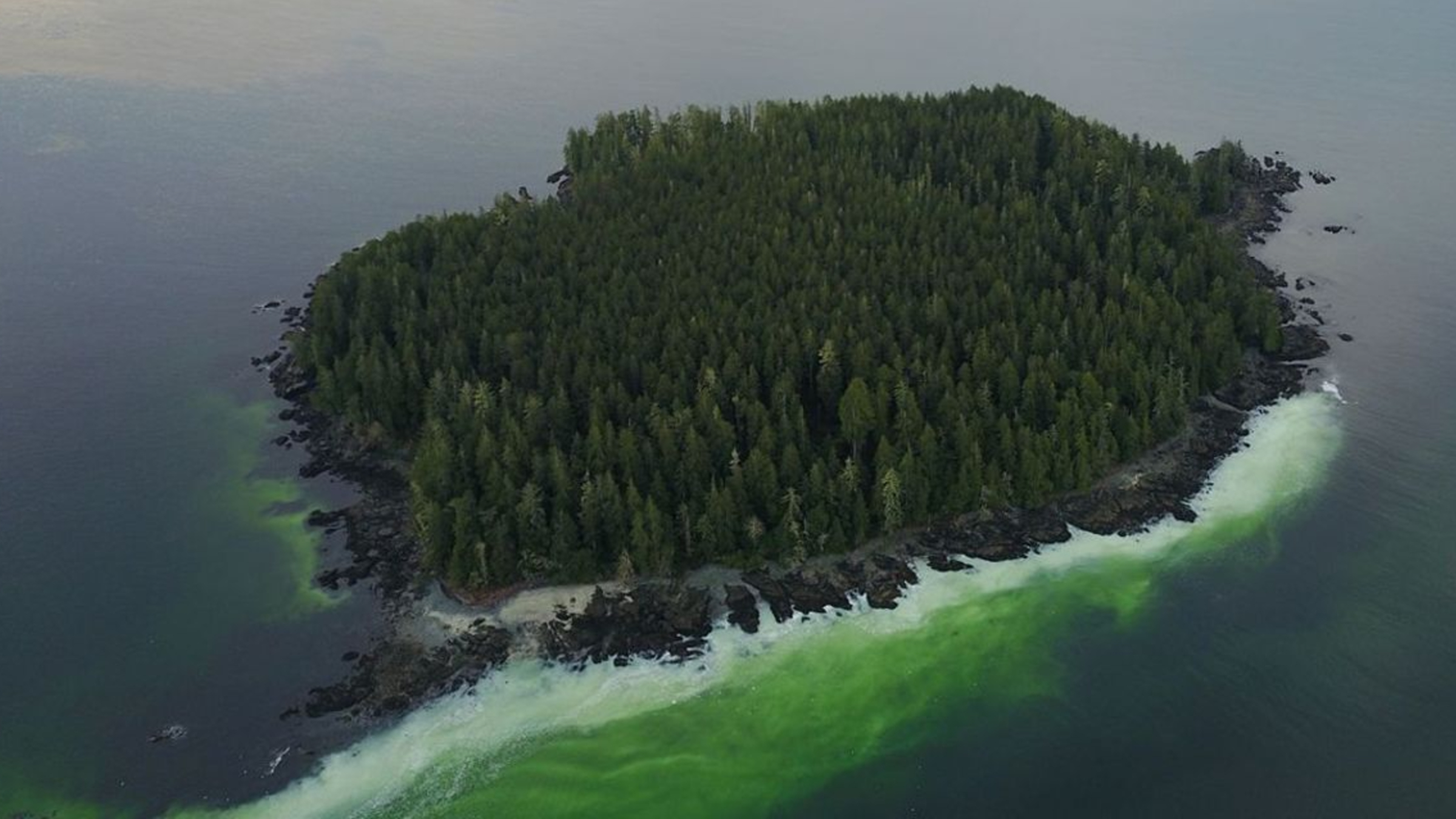
The milt appears green from above due to how wavelengths are absorbed by water as light reflects off the the white substance.
(Image credit: Ryan Cutler via Earth Observatory)
Coincidentally, this exact patch of ocean was the site of one of the weirdest oceanographic events ever seen. In 2020, around 4 miles (7 km) off the coast of Ucluelet (located just along the coastline to the left in the photo), scientists detected a rogue wave that appeared in the open ocean seemingly from nowhere. The massive wave reached the height of a four-story building, making it the most extreme version of this phenomenon ever seen.
Farther offshore, around 150 miles (240 km) south of Vancouver Island, researchers also detected a surprise swarm of more than 2,000 underwater earthquakes in a single day in March 2024, hinting that a section of the seafloor was ripping apart.