


Eerie new footage from the International Space Station (ISS) captures Hurricane Milton explosively intensifying into a Category 5 storm as it moves toward Florida.
The video was taken by one of the ISS’s external cameras as it flew over the hurricane at 10:28 a.m. EDT (2:28 p.m. GMT on Monday (Oct. 7). It shows the extremely dangerous storm’s pinhole eye and powerful 180 mph (290 km/h) winds, according to the National Hurricane Center. Pinhole eye hurricanes are storms with tiny eyes, just a few nautical miles in diameter, which can rapidly intensify to become extremely powerful and deadly.
“This is nothing short of astronomical. I am at a loss for words to meteorologically describe [to] you the storms small eye and intensity,” Noah Bergren, a meteorologist at Fox 35 Orlando, wrote on the social platform X. “This hurricane is nearing the mathematical limit of what Earth’s atmosphere over this ocean water can produce.”
Milton transformed from a Category 1 to a Category 5 in a matter of hours on Monday, defying hurricane models and stunning forecasters to become the fifth most intense Atlantic storm in recorded history. It has since dropped to a Category 4 storm, a strength it is expected to remain at until it makes landfall at Tampa Bay on Wednesday night (Oct. 9) or Thursday (Oct. 10) morning.
Related: We may need a new ‘Category 6’ hurricane level for winds over 192 mph, study suggests
This is far from the only footage of the monster storm captured from space. Images of Milton from the National Oceanic and Atmospheric Administration’s (NOAA) Geostationary Operational Environmental Satellite (GOES) show the hurricane spinning just above the Yucatan Peninsula.
The black and red toward the center indicate cold temperatures, which shows that convection — where heat and moisture are transported vertically in the atmosphere — runs deep, indicating more intense thunderstorms, according to NOAA.
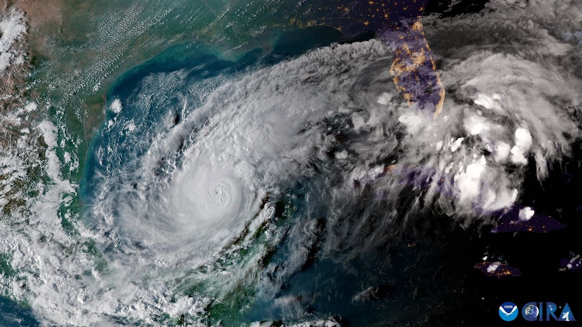
Meanwhile, chilling footage from the GOES-19 satellite, shared on X by Colorado State University’s Cooperative Institute for Research in the Atmosphere (CIRA), focuses on Hurricane Milton’s “powerful, small eye.” Another CIRA video also shows flashes of lightning bursting across Milton’s eye wall.
The incoming hurricane has prompted evacuation orders across Florida, which is still reeling from Hurricane Helene making landfall less than two weeks ago.
Since March 2023, average sea surface temperatures around the world have hit record-shattering highs. This not only makes for incredibly active hurricane seasons but also enables storms like Milton to intensify at unprecedented speeds.
“This is the most impactful storm we have faced, much stronger than Hurricane Helene,” St. Petersburg Mayor Ken Welch said at a news conference. “We already will be rebuilding for years because of Hurricane Helene, and that will be exacerbated by the impacts of this storm.”


